Satellite Image of Oil Spill in Rayong on Wednesday 31 July
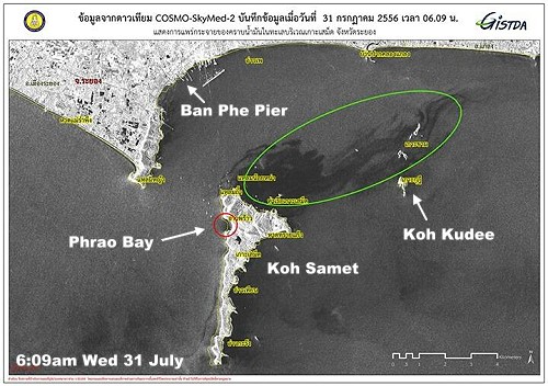
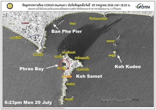
This is the latest satellite image released by GISTDA of the oil spill in Rayong province. The last image that we had (see below) which was taken on Monday night, it looked like the oil was heading for the mainland in Rayong. Indeed, some newspaper reports on Tuesday said that the oil had already reached some beaches. But, no-one provided any photographic evidence. Looking at this satellite image taken this morning, it would seem that the oil spill has moved away from the mainland and has started to disperse to an extent. However, what is worrying now is that it seems to have reached a group of islands dominated by Koh Kudee. These are a popular daytrip for tourists on Koh Samet to go snorkeling to see the staghorn and giant clam coral reef . Nothing in the news about this yet. It’s also strange that no satellite image for Tuesday was released. For all the latest updates on the oil spill, please follow me on Twitter @RichardBarrow.

I am most grateful for your comments I have read Re TubTim we have booked for xmas already again this year
There is no other place we have found to suit us and as a family of six I am concerned about the bad levels of mercury and any chemicals used to disperse the oil spill
Can you let me know if you can copy and paste any relevant info as and when it comes through PLEASE or point me in a direction of where to look
Thank you SO much
The happiness of many is determined for this year on the outcome
We love the staff at TubTim and it would be ghastly to abort our plans , but I read earlier what you said about before Ok
I also want to be damn sure the children will not suffer ANY effects , short or long term, Obviously many others feel the same Your help is invaluable and so kind
Best wishes and THANKS a lot
Sam Morse
Where is this place? I tried google maps and it seems to be on the mainland. If that is correct, then there was some cause for concern that the oil slick passed that way. It wasn’t affected much but is an area I would think twice before swimming. I would only advise at this stage to swim on the eastern side of the island. The tests they are doing are on-going but I should point out that at this stage they plan only to keep testing until October!
The govt has urged TAT and Thai media in general to put a positive spin on the disaster, so one may need to look elsewhere for the facts. Some foreign news sites have “blackened” the good name of Thailand with huge headlines such as “Paradise Lost” (The Sun, UK) causing the Kingdom to lose face and image.
Really? I haven’t seen a press release from the TAT yet and Thai papers are not painting a good picture. All the photographs are of the black oil spill without mentioning that hotels and beaches around the rest of the island are open as normal.As a consequence people are cancelling. Same happened in Ayutthaya after the floods and Hat Yai after the car bomb. I went down there the following week to give morale support. I guess I should do the same for Koh Samet.